Climate change is affecting the water cycle. As we have explored in this dossier, although water is abundant on Earth, it is unevenly distributed in terms of both time and space, and tensions over the resource are increasing as a result of uses and climate change. What is the situation in France? The Explore21 project – the results of which were published in summer 2024 – explores the possible future of water in mainland France according to the climate scenarios of the Intergovernmental Panel on Climate Change (IPCC). For various water resource indicators (river flow, groundwater recharge, etc.), future levels are estimated every 8 kilometres. Éric Sauquet, the project’s scientific co-leader, explains the results.
How is climate change affecting the climate in mainland France?
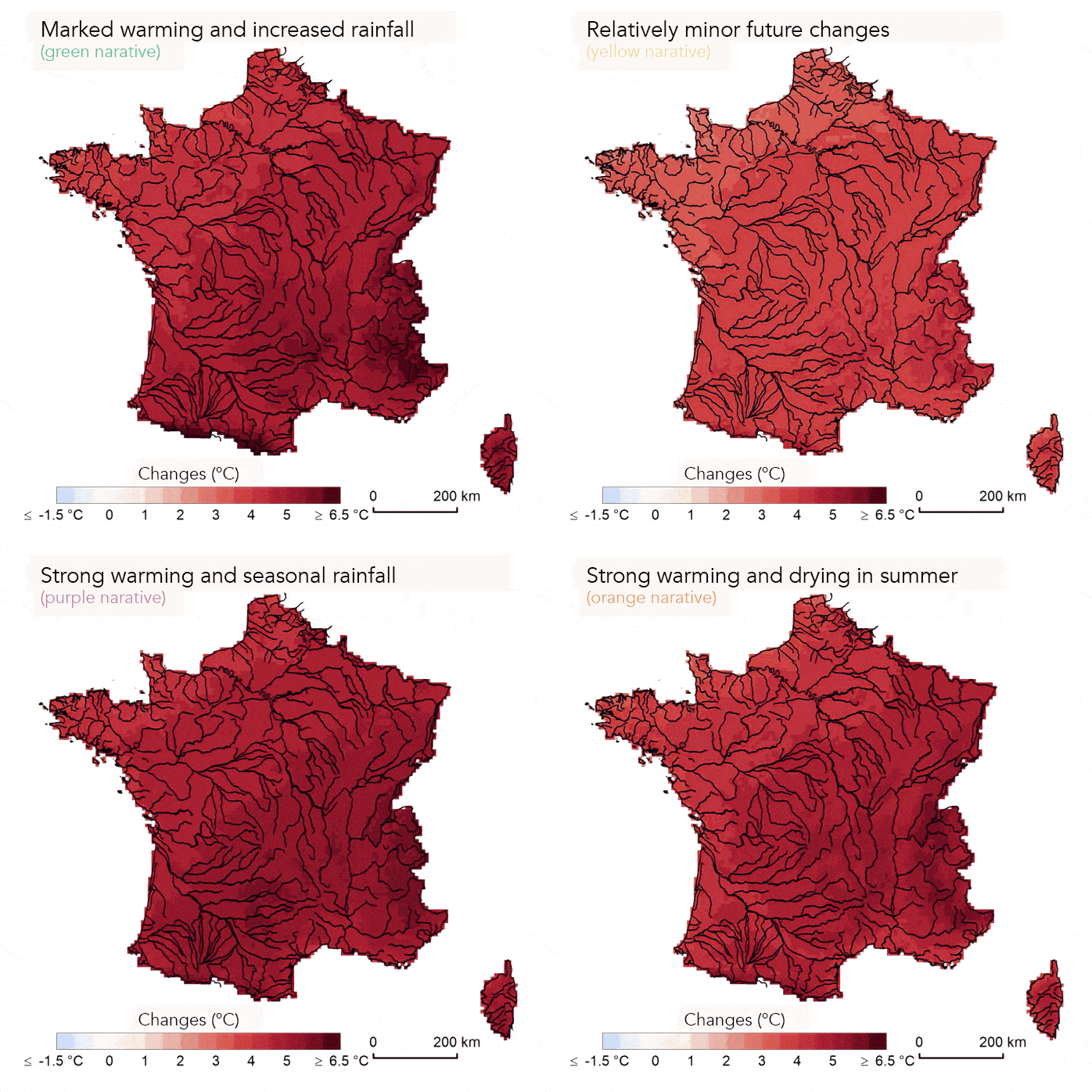
Éric Sauquet. Whatever our future greenhouse gas (GHG) emissions, the temperature will rise, and the more emissions we produce, the higher the temperature. In the Explore2 study, we considered three scenarios for future GHG emissions. I’m going to focus on the worst-case scenario, in which our GHG emissions continue to grow significantly (RCP 8.5). In mainland France, the models show that the temperature will be 4°C higher by the end of the century than it was between 1976 and 2005. The situation will vary from season to season, with higher temperature rises in summer than in winter. As for precipitation, it is likely to increase in winter and decrease in summer by 2100. The signal is not clear on an annual scale.
What are the consequences for water resources?
Changes in river flow reflect changes in rainfall. It is almost certain that a large part of mainland France will experience more severe low-water periods in summer, as a result of reduced rainfall and increased evapotranspiration. In winter, river flow will increase over a large part of the country due to the rise in precipitation. With rising temperatures, rainfall in the mountains will increase at the expense of snowfall: this will contribute to higher winter flows in the Alps, the Pyrenees and the Massif Central. On an annual scale, there is no clear trend in flows, with the exception of the south of France, where the models clearly show a reduction in annual flows.
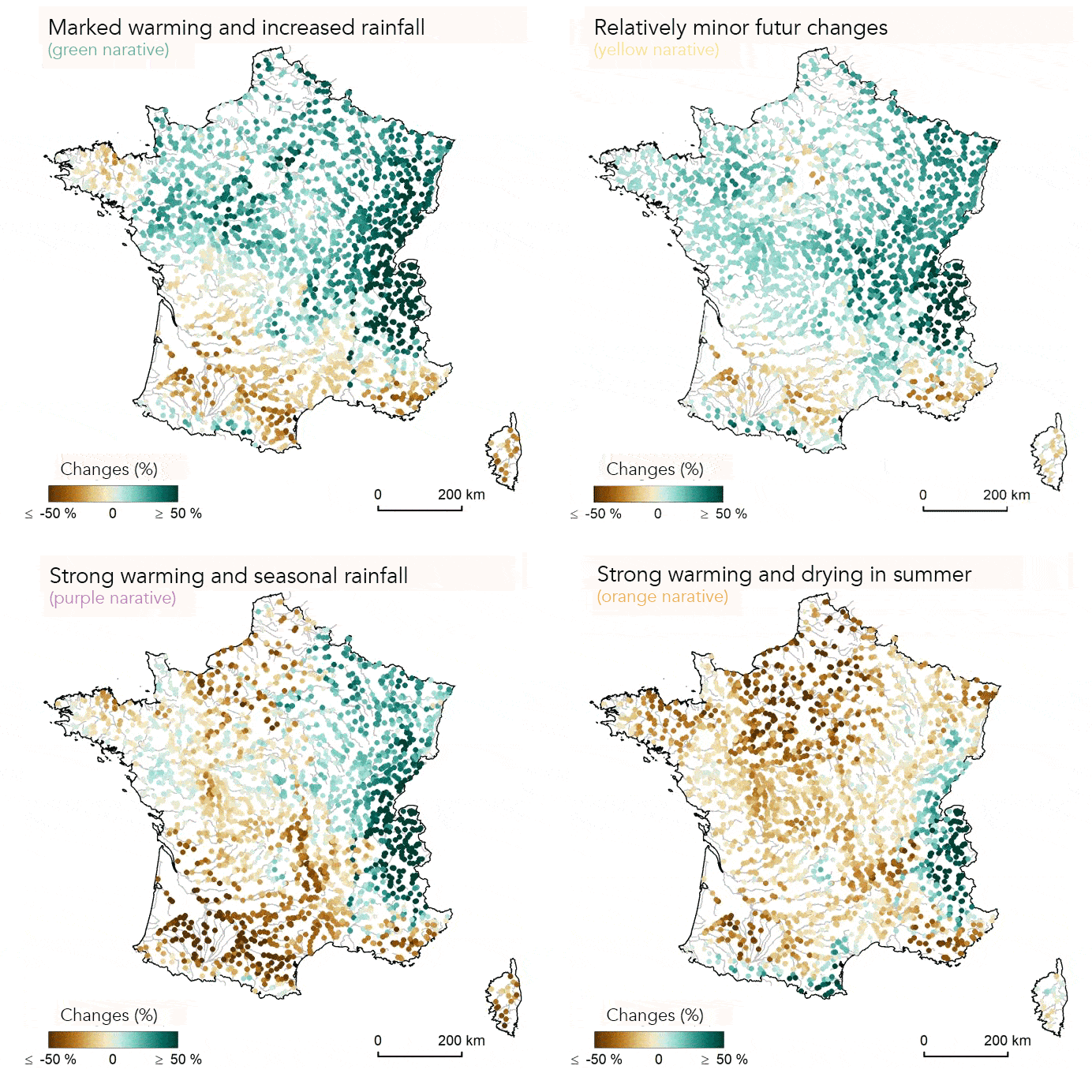
In winter, river flow will increase over a large part of the country due to the rise in precipitation. With rising temperatures, rainfall in the mountains will increase at the expense of snowfall: this will contribute to higher winter flows in the Alps, the Pyrenees and the Massif Central. On an annual scale, there is no clear trend in river flow, with the exception of the south of France, where the models clearly show a reduction in annual flows.
20% of the freshwater consumed in France comes from groundwater – the rest is taken from the surface2. Will this reserve also be affected by climate change?
Annual recharge of aquifers remains relatively stable between now and the end of the century for both sources, except in the north of France where the models project an increase.
In short, will some regions be more affected than others?
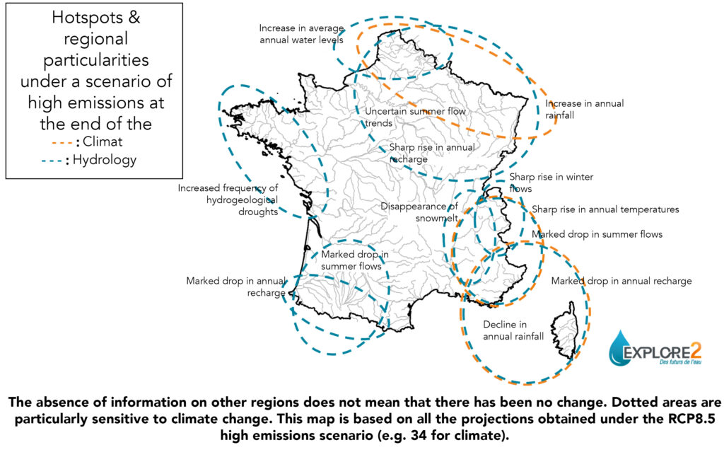
Water stress problems will become more widespread in mainland France, particularly in summer, due to the combined effect of lower rainfall and higher evapotranspiration. But France is large enough for spatial contrasts to emerge: we can identify areas that are more affected, known as “hot spots”. The south-east (including Corsica) and south-west will be particularly affected by a drop in annual water resources. The signal is less clear in terms of changes in summer flows for the north of France.
What are the remaining uncertainties about the future of water resources in France?
France is on the borderline between two major changes: in the north of Europe, rainfall is set to increase as a result of climate change; conversely, the Mediterranean basin is set to become drier. Is the transition between these two trends taking place in the north of France? Or in Belgium? It is still difficult to get a clear answer from the climate models. Another source of uncertainty for the north of France is linked to the natural dynamics of the region’s underground water tables: they store water in winter and release it in summer, increasing the flow of rivers. Will this process compensate for the summer droughts? Not all the models agree.
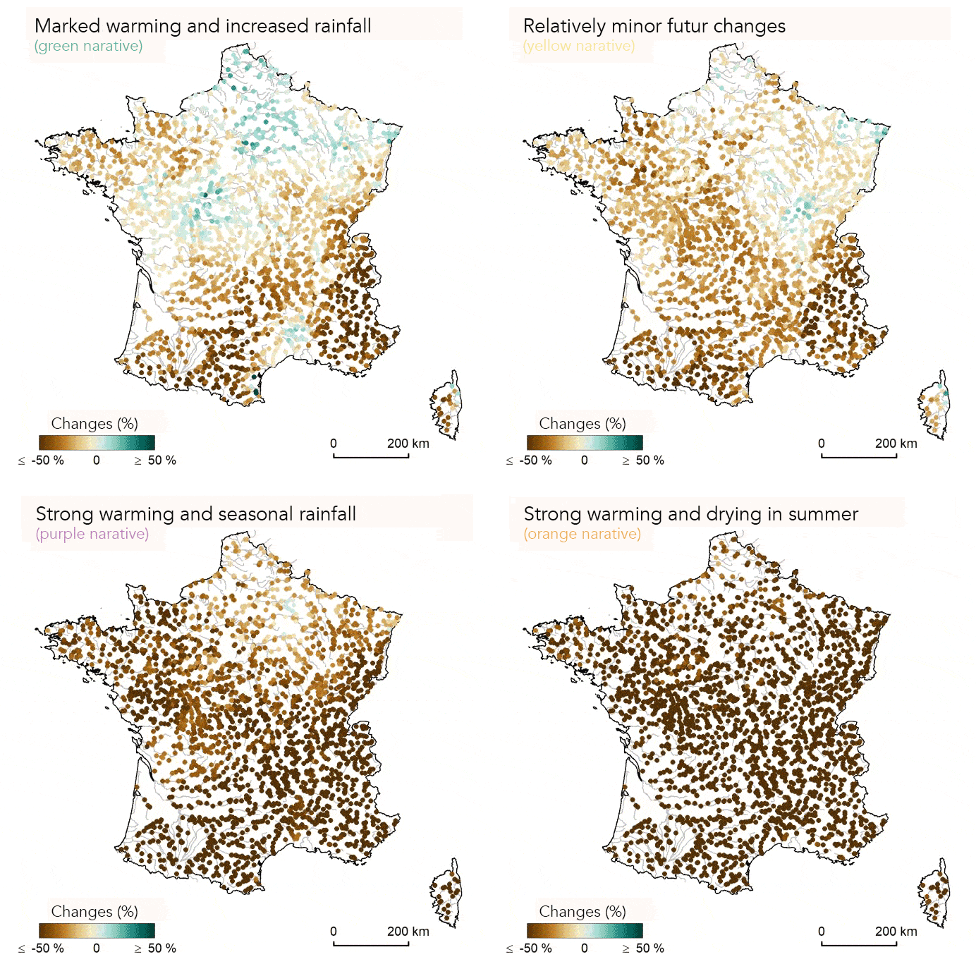
These uncertainties are clearly represented in the Explore2 results. Climate models provide us with information about the possible future climate in France at the end of the century under the impact of rising greenhouse gases. We have therefore chosen to retain four typical climates, the most contrasting. These are our four “narratives”: marked warming and increased precipitation (green); relatively little change in the future (yellow); significant warming and strong seasonal contrasts in precipitation (purple); severe warming and extreme dryness in summer (orange). For each hydrological indicator, four maps are presented to illustrate the projections according to each narrative. This enables local actors to imagine the future of their area, taking into account all the scientific results.
What are the solutions available to them to adapt to these growing pressures on water resources?
The first lever is to use water sparingly. The results of Explore2 show the need to adapt to the impact of climate change. We have made a digital platform available to everyone to facilitate access to the results. They can be used as a starting point for developing adaptation strategies. The existence of the data has already been mentioned in the Water Plan presented by the Government in 2023, and some of the projections have been used by the Rhône-Méditerranée-Corse Water Agency to diagnose the vulnerability of its territory to the effects of climate change.
The hydrological projections for the worst-case GHG emissions scenario (RCP8.5), which I have detailed here, illustrate the future if we do not mitigate our impact on the climate. This should also spur all players to take action to limit global warming, and there are many ways in which we can do so.


